Gold in them hills? Maybe it’s in South End
Envision this: A man draped in a cape, brandishing a gold-tipped cane, strolls through a 79-acre[1], 16-block chunk of South End. He’s costumed as the colorful Count Chevalier Vincent de Rivafinoli, an Italian gold-digger (literally) who swept into town during Charlotte’s early 19th-century gold rush, settled in a house at South Tryon and West Morehead streets, and apparently left a memorable impression on the city’s Scots-Irish Presbyterian settlers.
During his stroll – accompanied of course by his mascot, a golden retriever named Augie[2] – the faux Rivafinoli passes a Gold Museum, where visitors can peek into a historic mine, and he passes homes, offices, restaurants, hotels, even a bowling alley and skateboard park.
|
Learn More For those interested in more in-depth research, Gold District backers have set up a site where many documents are posted. Go to ftp://mail.odarch.com and sign in with username GoldDistrict, with password oda2014. |
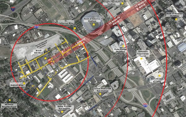
All that and more is the vision of a group of business and property owners in the area, which they are calling the Gold District. (To download a PDF of the map above click here.)
It lies in the northwest corner of South End, snuggled between the Wilmore neighborhood to the south and the Bank of America Stadium to the north. It’s a bit farther from the Lynx light rail line than most of South End, and hasn’t seen as much transit-related development. The area’s most well-known amenity might well be the venerable Little Hardware store.
But after gold was found in nearby Cabarrus County in 1799, early 19th-century Charlotte became the trade center of the first gold production region in the United States. Among the 700 gold mines in the Carolinas, two of the most prominent were the Rudisill mine near South Church Street and Summit Avenue and the St. Catherine near Morehead and Graham streets. The Brush Hill mine lay between those two. The mines, and the potential riches to be had, drew characters such as Rivafinoli, who was remembered as “a dandy.” Another was Thomas Penman, today memorialized with Penman Street. “He was kind of flamboyant, lived with his sisters,” says architect Stephen Overcash, one of the Gold District organizers.
The mines led to the U.S. Treasury locating a branch of the federal mint in Charlotte in 1835. That helped build the city’s prominence in banking and finance a century or more later. With the California gold rush of 1849 Charlotte lost its lead role in U.S. gold production, which largely ended early in the 20th century, except for a brief boost of interest during the 1930s Depression. (With today’s gold prices high, Romarco Minerals Inc., is trying to begin gold mining operations in Lancaster County, S.C., just south of the N.C.-S.C. line, at a site where others mined gold in the past. Read more here.)
The Gold District enthusiasts want to showcase the neighborhood’s gold-mining history as well as attract mixed use development, including plenty of stores, entertainment and recreational spaces.
Architect Overcash, whose Overcash Demmitt Architects firm is In South End and who has designed several South End buildings, has dug deep into the area’s mining history.
“You’ve heard the saying, ‘The streets of Charlotte are paved with gold’?” he asks. “When they would pull the rubble up (from the mines) they would pave the streets with it.”
Among those working with Overcash to pull together land use and other proposals are Caren Wingate, a marketing and land development consultant; land use and zoning consultant Walter Fields and former Discovery Place president John Mackay. They’re working in cooperation with Charlotte Center city Partners, which manages the Historic South End business development district, in which the Gold District lies.

One impediment to the kind of development they envision is the prevalence of industrial zoning in the area, which forbids residential uses. Fields is exploring the possibility of creating what’s called a zoning overlay district – a set of development and design standards tailored to apply only in a specific, designated area. Among the city’s existing overlay districts are historic districts, watershed protection areas, transit-supportive districts and pedestrian-oriented districts.
“We don’t need another plan,” Fields says. “We need a means to implement all the things people say we need.” An overlay district would avoid the need for a series of cumbersome, parcel-by-parcel rezonings, he says.
Other than a few historic markers, a mining display at the Mint Museum and some shallow “placer pits” (small surface digs for gold) still visible outside the Charlotte Museum of History on Shamrock Drive, little evidence exists today of the city’s one-time formidable role in gold-mining.
Yet the lure of gold is, seemingly, eternal – and the Gold District enthusiasts hope the romance of the yellow metal will help them breathe new life to an older part of the city.
[1] Why does the Gold District cover exactly 79 acres? Because on the periodic table of elements that’s the atomic number of gold.
[2] The name for “Augie,” the, ahem, golden retriever, derives from “Au,” the chemical symbol for gold.
