Metro changes affect Charlotte and regions across the country

Recent changes to the way metropolitan areas are defined added nearly a half-million in population to Charlotte’s MSA, making it the 23rd most populous MSA in the country. What happened in other metros across the country? Some saw great changes in their definitions, like Charlotte, while others remained entirely intact.
The Charlotte Regional Indicators project tracks a host of data for the 14-county Charlotte region. It also compares Charlotte’s metro area (which has always been a smaller set of counties than the 14 we track locally) to other “peer” metros across the country. This set of peer metros was developed from lists used by other local and national organizations but also took into account factors like population size and economic focus to find cities that would be most applicable to Charlotte.
These metros or MSAs (Metropolitan Statistical Areas) are established by the Office of Management and Budget based on data from the Census Bureau. Each MSA contains a core urban area of 50,000 people or more and consists of the county containing the core urban area and adjacent counties that have a high degree of social and economic integration (measured by commuting patterns) with the urban core (U.S. Census Bureau). Their boundaries are adjusted two to three years after each decennial census. The changes based on the 2010 census were just announced in February, and Charlotte’s MSA grew substantially (read more here).
How did these changes unfold in Charlotte’s peer metro areas? The following series of maps show how (if at all) each of the new definitions changed the composition of each peer metro area. Select a metro from the drop down box to pull up the associated map. (Scroll below the map for more information)
Maps by Zach Szczepaniak
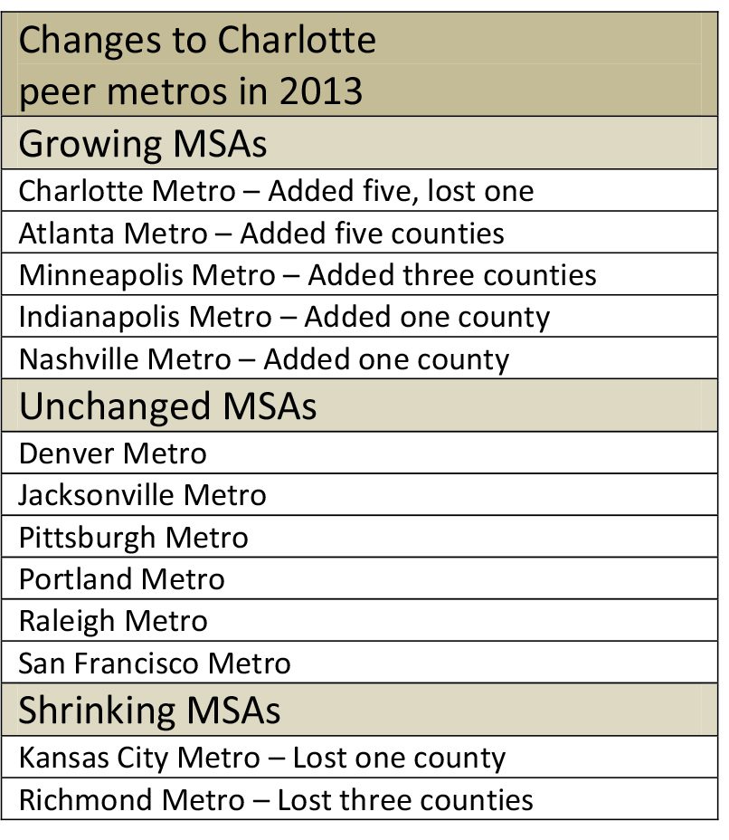 Of all of its peers, Charlotte experienced the greatest change, gaining five counties and losing one for a net gain of four counties. For a metro area that previously consisted of six counties, that is a substantial change. The new definition added counties to the north and south and produced more of a north-south alignment that stretches farther into South Carolina than before.
Atlanta’s metro grew by five counties in this latest revision, expanding eastward, subsuming Athens and the surrounding counties. Although this is a greater number than Charlotte added, the five added in Atlanta were on top of a metro area already consisting of 28 counties that covered almost a quarter of the state of Georgia.
The Minneapolis-St. Paul metro area also saw changes, picking up an additional three counties and expanding its reach to the north and southwest. The Richmond MSA saw the greatest change in the other direction, losing three of its 16 counties.
Other peer metros either remained unchanged from the previous metro boundary or added or lost a single county. A list of the changes is summarized in the table to the right.
Data posted in the future on the Charlotte Regional Indicators and in individual articles will begin to reflect these adjusted metro boundaries as those data are released.