Maps
The Renaissance Computing Institute (RENCI) at UNC Charlotte expanded the urban growth mapping and forecasting into 19 counties in the Western part of North Carolina: Alleghany, Ashe, Avery, Buncombe, Cherokee, Clay, Graham, Haywood, Henderson, Jackson, Macon, Madison, Mitchell, Polk, Swain, Transylvania, Watauga, Wilkes, and Yancey Counties. The final report maps historical development patterns from 1976-2030 […]
The Transportation Service Indicator Report is released annually by the North Carolina Department of Public Instruction (NCDPI) and compiled at the UNC Charlotte Urban Institute in cooperation with the Institute for Transportation Research and Education at North Carolina State University. This report summarizes operational data for every North Carolina public school district. Based on data […]
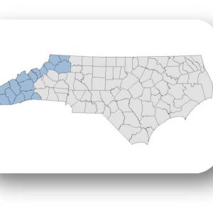
The Renaissance Computing Institute (RENCI) at UNC Charlotte expanded the urban growth mapping and forecasting into 19 counties in the Western part of North Carolina: Alleghany, Ashe, Avery, Buncombe, Cherokee, Clay, Graham, Haywood, Henderson, Jackson, Macon, Madison, Mitchell, Polk, Swain, Transylvania, Watauga, Wilkes, and Yancey Counties. The full research report is available in our web […]