Can Charlotte learn these lessons in time to save lower South End?
[highlightrule]Can lower South End survive the large-scale cookie-cutter development now ravaging South End and NoDa? Charlotte can learn some lessons from another Millennial magnet city, Des Moines. Yes, Des Moines. [/highlightrule]
In post-election America, consensus seems as unreachable as the lost land of Atlantis. Republican “Middle America” has triumphed over the Democratic coastal regions, and pundits agree this nation has rarely been more divided into urban versus rural sensibilities. But in the dominantly red heartland of the Midwest I recently found useful lessons applicable to Charlotte’s urban condition.
Nestled deep in America’s rural landscape lies Des Moines, Iowa. I’ve been visiting for 15 years as our elder son teaches history at a small college just outside the city. I have watched it mature from a city with no heart –a deserted office park for a downtown – into a thriving hub of entrepreneurial commerce with expansive, people-friendly urbanism.
At a little more than 210,000 in population, it’s less than a third the size of Charlotte (more than 827,000), but both cities are growing. While Charlotte this year was leading the nation as a destination for Millennials, according to one recent ranking, Des Moines is also a Millennial magnet due to low home prices and robust employment. It’s been ranked No. 1 in the nation as the most preferred destination for Millennials buying homes.
Like Charlotte, Des Moines is something of a blue haven in a state that seems to have turned deep red, and it’s seeing similar demographic changes. But there the similarity ends. For Des Moines has one huge advantage over Charlotte – and it’s nothing to do with politics.
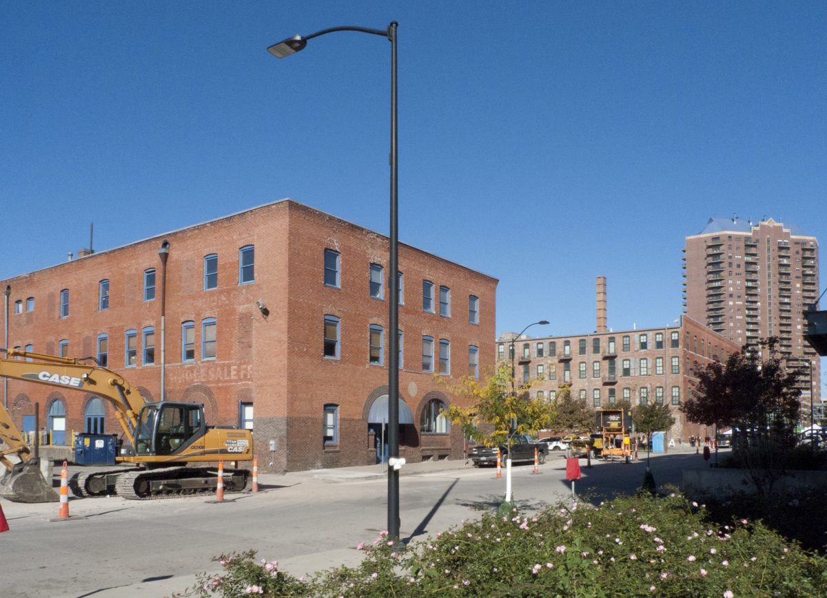
An ordinary old building in Des Moines’ East Village is renovated for residential and office use. In the distance, a refurbished factory and a more recent high-rise line the evolving landscape. Photo: David Walters
Des Moines has many blocks of old buildings, some fancy, others scruffy. That’s just what a thriving entrepreneurial city needs and what Charlotte lacks. In fact, the absence of those kinds of buildings within cohesive urban districts may be Charlotte’s Achilles’ heel in our race for sustainable future prosperity.
The famous urbanist Jane Jacobs described the vital importance of older, less fashionable buildings in her 1961 book The Death and Life of Great American Cities:
“Cities need old buildings so badly it is probably impossible for vigorous streets and districts to grow without them. … for really new ideas of any kind—no matter how ultimately profitable or otherwise successful some of them might prove to be—there is no leeway for such chancy trial, error and experimentation in the high-overhead economy of new construction. Old ideas can sometimes use new buildings. New ideas must use old buildings.”
That is one of the keys to getting ahead in the digital economy – opportunities for local entrepreneurs to start new businesses and network with others. A heritage of old buildings is important – and the scruffier and cheaper the better in some cases – but equally vital is the infrastructure of public space connecting them into a coherent walkable district. That means connected streets with sidewalks.
Des Moines has such a framework. Old buildings from the 19th and early 20th century line many blocks on a grid of streets in an area known as East Village. This district is a few minutes’ walk from the main business core across the Des Moines River, and when misguided plans for demolition threatened the Village in 2000, a group of local entrepreneurs saved approximately 30 blocks (between the State Capitol and the river), and set the scene for a process of dynamic, locally based urban revitalization.
[highlight]Read more: How Des Moines, Iowa, got cool[/highlight]
By the turn of the Millennium, the downtown core of Des Moines was showing signs of genuine life and activity, as a result of a catalytic plan proposed by the renowned urban designer Mario Gandelsonas. This vision, embraced by local businesses, rescued the city from the dull anonymity of post-World War II planning. Part of that plan envisioned that the “dilapidated east side neighborhood between the river and the gold-domed State Capitol should evolve into a ‘Red Brick City’ of storefronts and apartments.”
Within a 30-block area, East Village now incorporates an invigorated mix of new residential developments amid a variety of renovated old buildings. The older buildings, often of sturdy brick construction, house more apartments as well as a wide variety of local businesses – not just the usual suspects like restaurants and bars (of which there are several) but furniture stores, art galleries, a tea house, hotel, kitchen accessories shop, bridal shop, bath and soap store, jewelers, a clothing store, an Asian grocery store, a record shop, guitar shop, a pawn shop, a bank, a plumbing supply store, and a handcrafted letterpress printer.
The blocks have on-street parking and sidewalks, and many have mid-block alleys. When this system of connected and walkable public space is combined with a variety of small and mid-sized old buildings, you have the ideal conditions to support local, small-scale urban revival based around homegrown businesses.
It gets better. Beyond a set of railroad tracks lie another 18 blocks of partially vacant land, sharing the same fertile gridded infrastructure and ripe for a new crop of low-cost initiatives to take root.
WALKABILITY IS KEY – AND CHARLOTTE MOSTLY LACKS IT
These rich spatial networks are important. Walkability is at the core of sustainable city design, but this vital attribute is in short supply in Charlotte. We have energetic small businesses; we have entrepreneurs with ideas; we have creativity (and breweries) galore.
But we don’t have much in the way of public spatial infrastructure to support the growth of sustainable new urban districts.
Charlotte’s done a good job of retaining its older streetcar suburbs such as Dilworth, Elizabeth and the like, but beyond those gems a lot of its less fashionable built heritage has been torn down. That’s left us with only a few small fragments of older urban fabric – the kind valued by Jacobs for their “messy complexity.” We have a fragment of this mixed-up old urbanism on North Davidson Street in NoDa, but it covers only a few blocks around 36th Street.

Hundred-year-old buildings along Camden Road in South End, demolished to make way for a large office building. For several decades these old buildings housed artists and creative small businesses, now all evicted. Photo: David Walters
We did have an even tinier but similar fragment in South End along Camden Road, once the haven for the well-loved Common Market. Now that neighborhood gem has been bulldozed, along with other small businesses and artists’ studios that brought creativity to the area and people to the streets. (See photo above.) Individual businesses have been evicted to be replaced by yet another large corporation, whose grandiose office building will fill the whole block.
The old mill buildings nearby at Camden and Tremont thankfully have a robust new life as design offices, but the neighboring Atherton Mill is being subsumed by upmarket chain stores and soon will be dwarfed by out-of-scale apartment development.
This illustrates Charlotte’s problem. These fragments of old urbanism are so few that they become wildly popular and are soon claimed by developers, who rebrand them as high design and high-cost developments. As has happened in NoDa and South End, this effectively takes the old buildings off the market for start-up businesses, artists and other creative professionals, and the process often physically destroys the old buildings that helped create the neighborhood’s historic character.
While we appreciate Charlotte’s few old structures that remain, none really fulfills the need Jacobs defined: many blocks of older, scruffy and cheap property. By contrast, it seems a combination of history and timely vision has provided Des Moines with a head start over Charlotte in the race for sustainable grassroots urban redevelopment.
LIGHT RAIL BRINGS HOPE
Charlotte doesn’t have Des Moines’ combination of slightly shabby old buildings and connected, walkable streets. Our cheap, older buildings are stretched thin along faded and unattractive 1950s highways, like Wilkinson Boulevard or Freedom Drive, places that are hard to retrofit for innovative, walkable hubs of creativity and commerce.
But all is not lost. Charlotte does have the light rail line.
This far-sighted public investment has spurred billions of dollars of private development in up and down the line. So far, these new “urban villages,” NoDa and South End, have reoccupied neighborhoods that share some similarity with Des Moines’ East Village – connected networks of gridded and walkable streets and a few old buildings that have escaped the wrecker’s ball. But these areas have largely been overtaken by the cookie-cutter development of high-rent apartment blocks. There is a dramatic shortage of cheaper, older buildings.
Charlotte’s best hope for change is the LoSo area, or “Lower” South End. It’s generally the area between Tremont Avenue on the north (soon to be home to the new Common Market, with Sycamore Brewery close by) and Southside Drive about 2 miles to the south (near Olde Mecklenburg Brewery and Sugar Creek Brewing Co.). South Boulevard defines the eastern boundary and South Tryon Street, a third of a mile to the west, marks the western edge. The light rail line dissects the district. LoSo covers a larger but comparable area to Des Moines’ East Village and its adjacent underdeveloped blocks. But there the similarity ends.
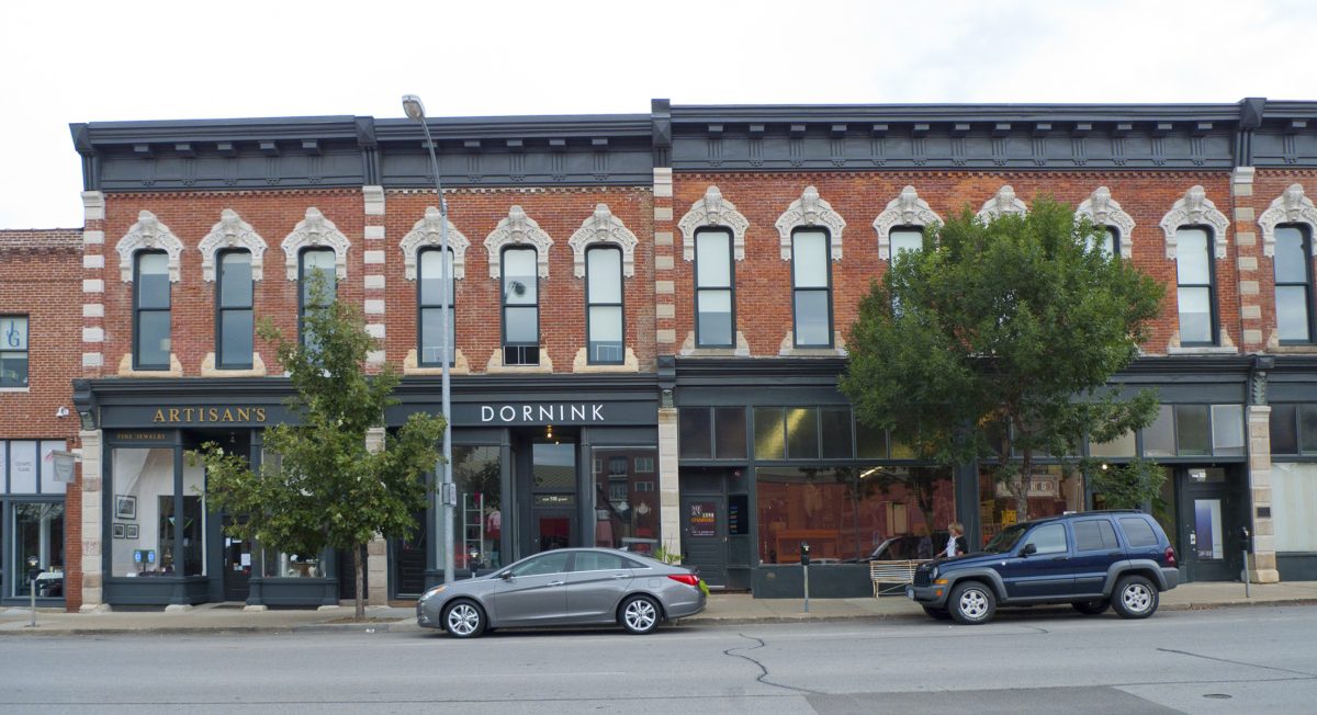
A row of 19th-century commercial buildings in East Village, Des Moines, today housing small businesses and idiosyncratic apartments. Photo: David Walters
East Village and its adjacent areas are defined by street grids. This infrastructure of connected public space is key to its success. It allows for a wide variety of development and uses, connected in a framework of buildings and spaces that support commerce in a neighborhood amenable to walking, cycling, driving and transit.
By contrast, LoSo was laid out after World War II strictly for the convenience of large trucks serving warehouses and businesses that occupied that whole area. The streets are excessively wide to accommodate turning semis, and there are no sidewalks. There is nowhere for a pedestrian to feel at home in public space. It was designed so that nobody on foot would interfere with the trucks. The blocks, such as they are, are long, with no coherent pattern. Cross streets were minimized to make driving the big rigs as easy as possible.
Nevertheless, LoSo is home to startup small businesses, new breweries like Sycamore and Triple C, and cooperative workspaces like C3 Lab. (Disclosure: My wife, Linda Luise Brown, and I are members at C3 Lab, using their shared studio and work spaces). There is still potential for more small-scale entrepreneurial activity, but the area is threatened on all sides by encroaching residential development of the kind that largely destroyed the fleetingly special character of South End.
What can be done? It’s a quandary.
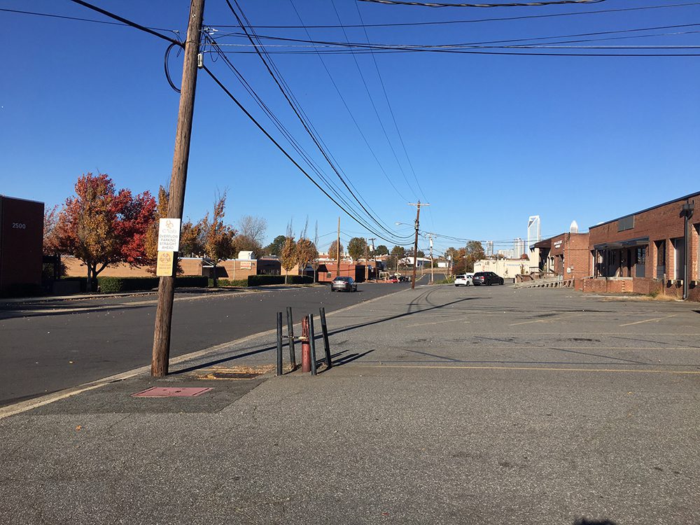
Is there hope for Lower South End? This wide stretch of asphalt on Distribution Street shows how the area was designed for truck traffic decades ago. Today the opportunity exists for street improvements to support a better pedestrian environment. Photo: David Walters
It would be physically possible – but difficult– to retrofit much of the area with an improved and connected network of narrow streets, sidewalks – and the occasional little courtyard – all threaded between existing buildings. That would set up an infrastructure of walkable and bikeable spaces linked to the two light rail stations and the Rail Trail beside the tracks, and would encourage pedestrians.
That’s very costly. It would need dramatic action from the city to create a master plan and to purchase rights-of-way to carry out the plan. It would mean retrofitting those truck roads with sidewalks, medians and crosswalks wherever possible. But even if we did all that and “improved” the district, we would likely be sowing the seeds for exactly the kind of large-scale redevelopments that drown local businesses under new waves of apartments.
ONE SOLUTION: PROACTIVE REZONING TAILORED TO THE AREA
Much less expensive would be for the City of Charlotte to do some proactive rezoning of the LoSo area – to put in place what’s known as an “overlay” zoning district, tailored to that area. The zoning would, most importantly, specify a maximum lot size (relating to property boundaries that currently exist). This would maintain the scale of the area and keep the pattern of multiple ownerships. The aim of this overlay zone would be to prioritize small-scale redevelopment – the adaptive reuse of existing buildings – exactly the kind of transformation that works for the new breweries and startups like C3.
Retaining this fragmented pattern of ownership would be a major impediment to developers bent on acquiring multiple parcels for demolition and large-scale new projects and it would prioritize finding creative new uses for these cheaper, older properties. At the same time it would remove the uncertainty tenants have that the buildings they occupy might be sold out from under them. That uncertainty stifles creative investment in future, start-up business ventures.
POLITICAL COURAGE REQUIRED
If that city action was paired with sidewalks, street improvements such as “road diets” to slow traffic, and perhaps the occasional pedestrian cut-through between buildings to and from the rail trail, we would create an approximation of the conditions Jacobs described and Des Moines enjoys.
This action would be controversial, requiring political courage. Property owners might complain such zoning frustrates their hopes to sell to high-bidding developers. But that scenario isn’t a foregone conclusion. It can be expensive and time-consuming for developers to acquire and hold separate purchases over several years while trying to persuade different owners to sell – with no guarantee of eventual success. Meanwhile, there are larger properties across Tryon Street already ripe for high-density, mixed-use development. Remember: for South End to be sustainable, people living in apartments must have places to work nearby. Small, innovative businesses have to figure into the mix. The alternative is for all the promise of LoSo to dissolve into a dull apartment suburb that will fade into anonymity once the Millennial boom passes.
The buildings in LoSo are simple, predominantly single-story brick boxes, lacking architectural character on the outside; but they are robust and provide opportunities for creativity inside, under long-span bow trusses and high ceilings. And they are 50 years old. In Charlotte that counts as historic. Wouldn’t it be great if those same buildings didn’t get torn down and lived on to be 100 years old? Or 150? Unlike other cities that enjoy a preserved architectural legacy that’s ripe for reuse, Charlotte has to reinvent its own history, almost from scratch. These LoSo buildings served companies well in a 20th-century economy and, with some help, can adapt to thrive in the changing conditions of 21st-century commerce.
Lower South End provides a fascinating urban laboratory for creating sustainable cities. Des Moines teaches us that the most sustainable elements of cities are its existing buildings, redolent with history and waiting to be filled with promise for the future.
Can Charlotte learn the lesson?
David Walters is an architect and town planner, professor emeritus and former director of the Master of Urban Design Program at the UNC Charlotte College of Arts + Architecture.
Opinions in this article are those of the author and may or may not reflect those of the UNC Charlotte Urban Institute or the University of North Carolina at Charlotte.