Can innovative interchange plan survive suburbia?

With the long-delayed final leg of Interstate-485 set to open soon, residents near the new interchange at Prosperity Church Road are bracing for growth. The question is, what will that growth look like?
A 15-year-old plan calls for an “urban village” of compact streets and walkable, mixed-use neighborhoods. When envisioned in the late 1990s, it had the potential to become a national model as a different way to allow development at interstate interchanges. The plan would not create the typical pattern of gas stations, strip centers and other businesses built to serve only people in cars, surrounded by a jumble of apartment complexes and surface parking lots. Instead, the vision was a walkable neighborhood with a sense of place, as opposed to what was taking place along the southern leg of the highway: big boxes, miles of cul-de-sac subdivisions and massive congestion.
But after a controversial rezoning or two, increasingly vocal opposition to any new multifamily developments from neighbors and more than a decade of suburban-form growth in the once-rural area, some insiders wonder whether the plan – and any hope of walkable development – still has a chance.
* * *
Crews have been building Charlotte’s outer loop highway, Interstate 485, a few miles at a time for a quarter of a century. Begun in 1988, the first segments opened on the more developed southern side of Mecklenburg County. As each of 29 interchanges opened, conventional suburban development followed – gas stations, strip malls, subdivisions. And traffic. Lots of traffic.
In the mid-1990s, with about 10 miles and a handful of interchanges built, a few Charlotte leaders began to question whether the loop highway had really been a good idea. The highway had too many interchanges, some said. It was pushing development farther from the urban core. And the early experience in southern Mecklenburg County, as well as other U.S. cities, was that it lured so much development it was causing more traffic congestion, not alleviating it. In 1998, an expert in urban regional development from Atlanta even suggested the loop shouldn’t be completed. No one took that idea seriously, though.
“It was the first time anyone had ever heard that,” architect and planner Tom Low recalled. “They had just heard ‘growth is good.’ Every place in the country was building beltways and choking on sprawl.”
Low was just out of graduate school at the University of Miami, where he had worked with the New Urbanist architect firm Duany Plater-Zybek. In Charlotte, working for DPZ, Low became an activist for traditional downtown design and walkable urban developments. He helped develop plans for Belmont’s Main Street and new developments in Davidson and started “pushing the agenda,” as he put it, for new urbanism in the area. He had some support in the Charlotte Urban Forum, a group of planners and architects who met regularly to talk about New Urbanism. One member was Warren Burgess, a project manager for the Charlotte-Mecklenburg Planning Commission.
Burgess had an idea. If I-485 was going to happen anyway, why not encourage a more urban form of development near at least one of its interchanges, instead of standard suburban sprawl? With development spreading throughout the county and Mecklenburg’s population steadily on the rise, the Prosperity Church Road area was one of the few undeveloped areas left. Burgess called Low. He and a few others came up with a plan.
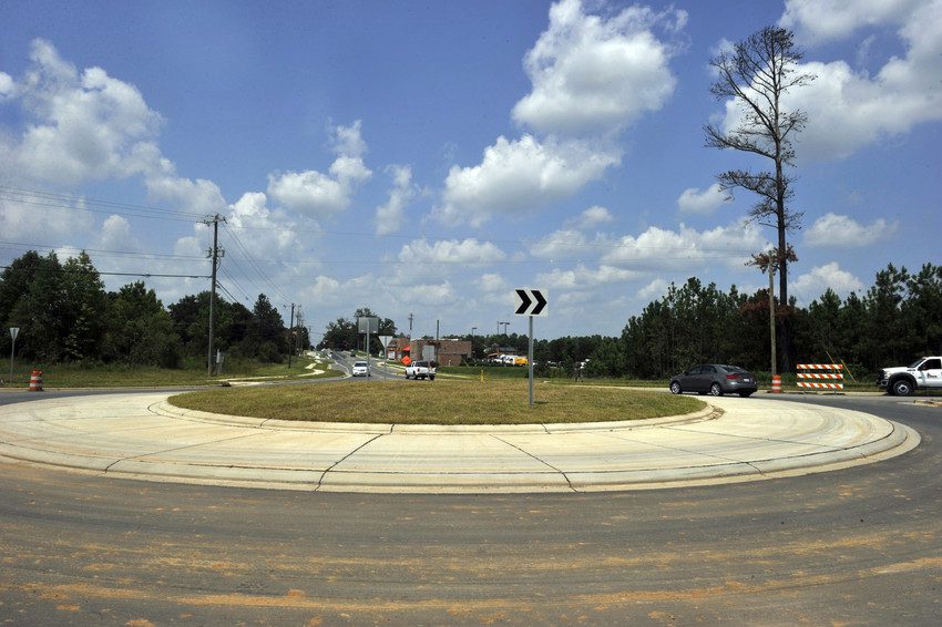
Instead of widening Prosperity Church Road to six lanes and creating a standard interchange, the plan would create three two-lane roads, two for highway access and one for through-traffic on Prosperity Church. As the area grew, developers would fill in an urban street network as they built out projects. The area directly around the interchange would be zoned for higher density projects that would include stores, offices and homes close together, mixing uses that conventional suburban-style zoning keeps apart. The development intensity would gradually decrease farther from the interchange, tapering into single-family housing at Eastfield Road.
“The notion of doing something like that was unheard of,” says Walter Fields, a planning consultant who worked for the Charlotte-Mecklenburg Planning Commission until 1997.
In the mid-1990s, the area around the proposed interchange consisted of 30 single-family homes, a mobile home park, two convenience stores and hundreds of acres of farmland that had been in the Oehler family for generations.
“People that own farms don’t necessarily trust planners,” said Bill Coxe, a transportation planner with Huntersville who was working for Mecklenburg County at the time of the plan. “Warren struck up a friendship with many of the landowners there. They trusted him.”

It was harder to convince the N.C. Department of Transportation. Fields recalls visits with Burgess to board of transportation members to seek their help.
Planners from the city and county and the engineers from NCDOT spoke different languages, Coxe said. One focused on land use and urban design, the other on traffic flow and congestion management.
“The state said, ‘We don’t do land use,’ ” Coxe said. “Well, yes you do; you just don’t acknowledge it.
“So, NCDOT was skeptical, but there is a concept called a split-diamond interchange. There is one in downtown Charlotte between Trade and Fifth (streets) where basically you have parallel roadways one way on each side … That surface street between those two roadways can function more like a city street.”
Once NCDOT approved the split-diamond interchange, which allowed for the three parallel roads, Burgess and Fields took the lead in writing a small area plan for the urban village concept. In 1999, the Mecklenburg Board of County Commissioners approved the plan, because the area at the time was not incorporated. The plan called for pedestrian-oriented urban design standards such as sidewalks, bike lanes and street-facing buildings. Small area plans are supposed to guide rezoning decisions, but they are not legally enforceable and elected officials need not follow them.
Then, the planners waited. Funding and construction delays set back I-485 construction, and the Charlotte area continued to grow. Single-family subdivisions popped up along Prosperity Church Road. The Highland Creek subdivision on the Mecklenburg-Cabarrus County line continued to build out. Retail developers followed. Burgess moved on to become the town planner in Davidson. He died in 2008.
A Harris Teeter shopping center opened in 2000 at Prosperity Church and Ridge roads. A Bi-Lo followed a block away. While the subdivisions conformed to the plan, they did so “only on the margins,” according to Kent Main, an area planning coordinator with the Charlotte-Mecklenburg Planning Commission. “It did not alter the plan, but it did alter the facts on the ground,” said Main.
In 2002, developers proposed another grocery-store-anchored shopping center at Eastfield and Prosperity Church roads. Eastfield Road, the dividing line between Charlotte and Huntersville, was just outside of the Prosperity Villages small area plan’s limits.
Huntersville planners, the Charlotte Department of Transportation and the Charlotte Area Transit System protested, saying a retail center at Eastfield would disperse growth to an area that was supposed to remain single-family residential. In turn, that would reduce the chances of attracting dense urban development around the interchange. But the city planners supported the proposal, and the City Council approved it.
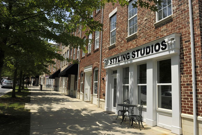
“The Eastfield Center sort of extended the boundaries (of the urban village plan),” said Kent Main. “Of course, that has diluted the ability to get more urban form as well. The development does have some (urban) elements of buildings to the street and live-work units, which we show pictures of and tout as a model for what we’d like to see in the urban village at the interchange.”
Growth came to a stop in 2008, with the financial crash. But with the interchange scheduled to open, Main started working with area residents to update the 1999 small area plan.
|
Read about the plan Click here to see information about the Prosperity-Hucks Area Plan, and click here to download the draft plan. |
“We were ready to take it to council in February,” Main said. “Suddenly, a whole raft of concerns started emerging.”
Most of the concerns were about a rezoning petition by the Halvorsen Property Group to develop 38 acres at Prosperity Church and Ridge roads for a 100,000-square-foot retail development anchored by a Publix grocery store and up to 292 multifamily units.
Area residents signed online petitions and packed meetings about the plan and succeeded in delaying its hearing at the City Council. Main said planning staff will hold more meetings with residents in early September. The public hearing for the Halverson rezoning was pushed back to Oct. 20.
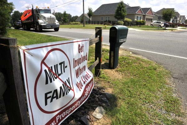
Even outside of the plan’s boundary on Eastfield Road, a large banner decrying multifamily housing hangs on the entrance to a long rural driveway. Some neighbors wanted no multifamily at all. Others were more concerned about the specifics of the plan, saying they were promised a mixed-use center like Birkdale in Huntersville, with apartments above street-level shops – not the three-story walk-up apartments proposed in the Halvorsen rezoning.
“There are people flat out opposed to anything that is rental or with two or more units attached on anything less than a third of an acre,” said Theresa Rosa Corey, an area homeowner who leads a group opposed to the Halverson plan. “But most people that we will speak to are very much proponents of smart growth. We don’t mind residential over retail, or townhomes. But we are very much against the garden-style apartments (Halvorsen) is proposing. It takes this giant chunk of land that could be put to better use. We’ve been waiting for many, many years (for better retail). We are looking for a place where we can come together as a community … There’s nothing about the (Halvorsen) plan that makes me want to linger.”
Low, the architect, says he understands why people might oppose apartment development, even though he doesn’t agree. “When people hear the word multifamily, they think a bunch of box cars strewn around randomly in a sea of parking where you have no connection to civic life,” said Low. “You can do great multifamily, but that’s just so foreign to anyone in a suburban community. If I were them, I wouldn’t think it was possible.”
A Birkdale-like center is unlikely, said Main, the city planner. Birkdale was built by one developer on a single piece of land. In the Prosperity Church Road Villages, individual property owners and developers will gradually fill out the new street network. That makes consistency of development styles even more important, Main said.
“We have to come up with a framework or a network that is going to hold this village plan together and make sure that what we build lives up to that,” Main said. “You’ve got to get individual developers to do that on a one-on-one basis.”
Meanwhile, a new Pep Boys mechanic shop is set to open at the Eastfield Village Center. Across the street in Huntersville, crews are putting the finishing touches on a Walgreen’s in an area the used to be zoned rural.
“Basically, everything has been done half-hearted,” Low says. “You have to have champions, and I don’t think this project has a champion.”
