How to find information on your neighborhood
The new Charlotte-Mecklenburg Quality of Life Dashboard gives information on a variety of neighborhood conditions, providing some of the most extensive neighborhood-level information available in the United States. The report is different this year in several ways: it covers a larger area, has many more data items and all the previous neighborhood zones have changed.
For more information
Read an interview with Owen Furuseth about the Quality of Life project: click here. Want to identify your neighborhood in the new dashboard? Click here.
The online dashboard allows the user to click on any neighborhood to see data, and identify a neighborhood using a specific address. Future articles from the UNC Charlotte Urban Institute will explore the neighborhood data in greater detail. Below, the additions and changes to neighborhoods are described and cross-referenced to prior reports.
Changes to existing neighborhoods
Previous Quality of Life reports were organized around neighborhood units with familiar names like Beverly Woods, Cherry or Plaza Midwood. This year, the information is broken out into many more geographical areas, so that one neighborhood may take in several Neighborhood Profile Areas (NPAs), which have numbers, not names. The Beverly Woods neighborhood, for instance, in earlier years was listed by name, and in 2010 had the ID number 182. For this year’s report, the Beverly Woods neighborhood is made up of NPAs 44, 143, 213 and 359 (see map below).
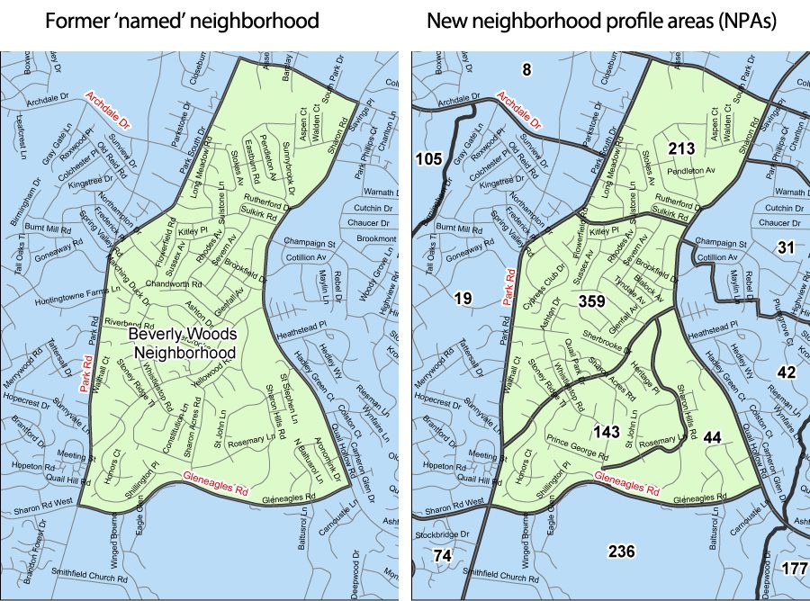
Researchers at the UNC Charlotte Urban Institute have used the NPA data and previous years’ Quality of Life reports to compile a guide to neighborhoods, by name. At the bottom of this article, a lookup is provided to show the numbers of the new NPAs that comprise the former “named” neighborhood boundaries in Charlotte (click here to go to the neighborhood lookup tool). Creating the new boundaries for the areas that had previously been named neighborhoods was a detailed process that compared census block group geography to neighborhood boundaries and boundaries from the planning commission. Public meetings were used to include feedback from the community in the determination of the final lines for the new NPA boundaries.
Covering new territory
Previous Quality of Life reports covered only Charlotte and the unincorporated areas where Charlotte has zoning authority. This year the 2013 Quality of Life report includes all of Mecklenburg County. Creating new NPAs for the towns and unincorporated areas around Charlotte also started with census block group geography and incorporated input from the town, which each have zoning authority beyond their town lines. The map below shows the new NPAs for the town of Mint Hill.

Maps of other towns in Mecklenburg towns that have not had Quality of Life neighborhood until this year are also available. Click town names below to download PDF maps of those NPAs:
Cornelius, Davidson, Huntersville, Matthews, Mint Hill and Pineville (click to download PDF map).
Views of individual neighborhood profile areas are best done on the interactive Quality of Life Dashboard. The map interface can be used to determine NPA by address. A map of Charlotte was not created due to the large number of neighborhood profile areas in its jurisdiction.
Quality of Life Neighborhood Lookup – As part of a major revision and expansion of the project this year, the previous neighborhood boundaries in Charlotte’s jurisdiction have been extensively revised.
Select the previous neighborhood name from the drop-down below to see the new neighborhood statistical area numbers that now make up that neighborhood. To find your neighborhood profile area by address, go to the Charlotte-Mecklenburg Quality of Life Dashboard.