How our changing landscape sustains us all
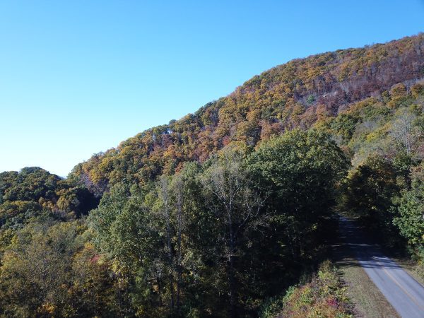
Ecosystems such as forests and wetlands provide clean air and water, food, building materials and recreational opportunities. The benefits people receive from nature are referred to as “ecosystem services.”
Our interactions with ecosystems can have a positive impact, boosting our health and the economy. We can also have a negative impact on the health and survival of these natural resources.
Many of the decisions we make, from how to develop community infrastructure to managing the land surrounding our communities, impact ecosystem services. But we are not always aware of the links between our environment and our well-being, and we may not always take the value of ecosystems into account in our decision-making processes. Understanding the value of ecosystem services can help us better manage our resources in a way that benefits us economically, environmentally, and socially.
The Carolinas Urban-Rural ConnectionA special project from the UNC Charlotte Urban Institute |
|---|
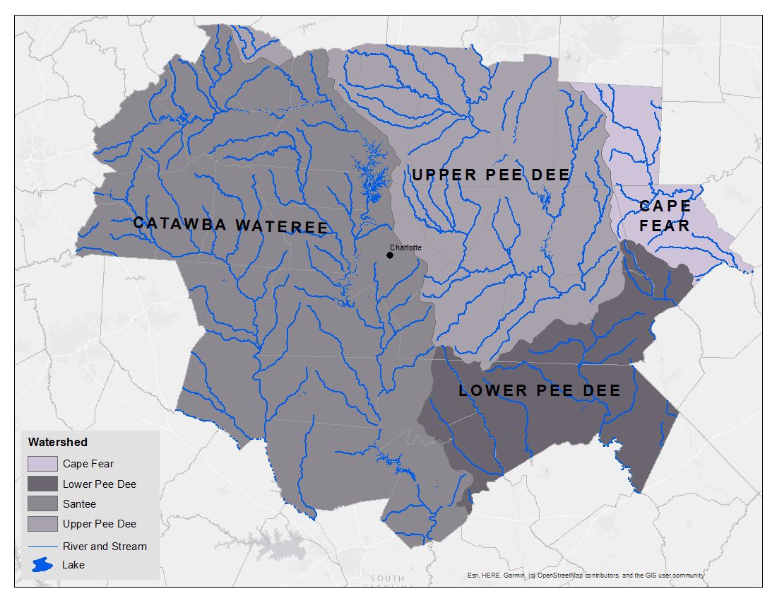
Managing and protecting natural resources is complicated, because people that benefit from an ecosystem service often live many miles away from where the service is produced. For example, clean water that starts in the Blue Ridge Mountains and flows through the Pisgah National Forest forms the headwaters of the Catawba-Wateree River Basin, where it enters Lake James and flows through streams and rivers, downstream to the edge of the water basin located southeast of Columbia, S.C. This ecosystem service provides drinking water to 2 million people who reside in the 5,000 square mile watershed area.
These ecosystem benefits also include energy supply, agriculture, recreation opportunities and the protection of aquatic life along its 225 mile long journey. As the water supply travels over land and through waterways, its water can become polluted, diluted, cleansed or filtered by vegetation. People downstream may benefit from services produced far upstream — or may pay the costs of decisions made somewhere else along the way.
To learn more about how ecosystems affect us, the USEPA Enviro Atlas is designed for all levels of government, environmental and public health professionals, researchers, educators, non-governmental organizations and anyone else with an interest in ecosystem services and their role in sustainable and healthy communities. Using the USEPA Enviro Atlas model can help users better understand the interdependence of urban and rural communities and how to support ecosystems and the natural processes that provide critical benefits to society.
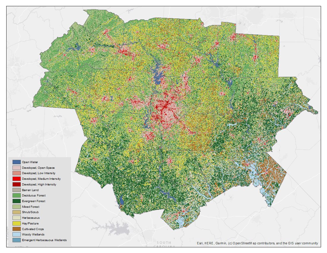
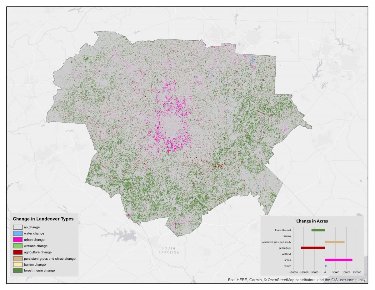
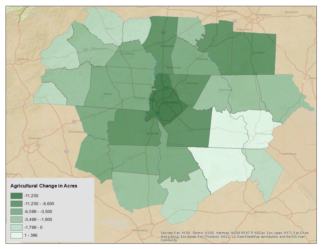
Here are five maps that show some of the crucial components of ecosystem services in our region. Click each map for a larger version:
The 2016 land cover map clearly shows the urban core centered on Charlotte. Close-in suburban counties are seen as less dense urban areas surrounded by scrub and shrub lands with portions of forested areas. The rural counties,or the third ring of communities from Charlotte, reflect mostly agricultural and forested lands.
The 32-county study region has experienced land use changes between 2001 and 2016 that lead to a loss of forested and agricultural lands and an increase in urban and grass and shrub lands. Most of the urban land use change has occurred around Charlotte, while the forested land use change is occurring throughout the suburban areas surrounding Mecklenburg county.
Overall, 29 of the 32 counties lost agricultural land during the 2001-2016 time period. Three southeastern counties have experienced a slight increase in agricultural lands: Anson and Richmond County in North Carolina and Chesterfield County in South Carolina. The most significant loss of agriculture lands is in Mecklenburg County, followed by the adjacent counties of Cabarrus, Iredell and Union in North Carolina and York County in South Carolina. The northeast counties of Davidson and Randolph are also experiencing significant agricultural land loss, perhaps due to their proximity to the urban areas of Winston-Salem and Greensboro.
There are four major water basins associated with the study region: Cape Fear, Lower Pee-Dee, Upper Pee-Dee and the Santee, which includes the Catawba-Wateree basin system, the main water system serving the region. The water basins include 2,923 miles of rivers and streams and 91,443 acres of lake area.
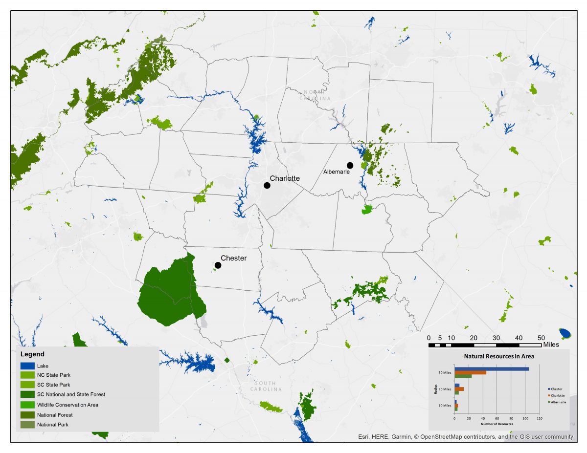
Some ecosystem service benefits are hard to see in our day-to-day lives: climate change protection, wildlife habitat conservation, tourism dollars, and preservation of history and cultural values. Access to natural parks and lakes from Charlotte, Albemarle and Chester, South Carolina indicates our proximity to these ecosystem services within 10, 20, and 50 miles.
Whether you reside in an urban, suburban or rural area we are all dependent upon and benefit from ecosystem services. These connections do not rely upon jurisdictional boundaries. Ecosystem services are regional connections we all need to protect and respect.
Further reading
Benefits of agriculture ecosystem services
To learn more about a regional effort to help strengthen farming and the importance of attracting more young people to invest their careers in growing food read: A ‘crisis that’s brewing’: How this program plans to help NC farmers
To learn more about the ecosystem service benefits and impacts for urban and rural consumers, as well as regional social well-being and economic connections read: Connecting our region through local food systems
To learn more about how the large geographic range that restaurants must go to in order to source local food may benefit urban-rural connections through economic linkages read: Farm-to-table: A trendy-but-tenuous urban-rural connection
To learn more about ‘intermediaries’ the entities that move and process food from farms to table and their importance in the regional food system read: Why intermediaries are key to viable local food systems
Drivers of change
To learn more about the importance of studying the area which Charlotte regularly depends on for food, water, workers and recreation, as well as the area which frequently depends on Charlotte for jobs, transportation, goods and entertainment read: Defining our study area: How we picked the 32 counties
To learn more about how people and industries in the study area followed trading paths, railroads, highways and, now, air service as drivers of change read: Trails, roads, rails and sky: The changing physical connections that knit our region together
To learn more about how the South Fork of the Catawba River has fueled the quality of life and economy for the region read: From textiles to trails: A river’s changing path to prosperity
Natural resources
To learn why the Carolina Thread Trail, Cross Charlotte Trail and greenways are critical regional ecosystem service connections read: Forging connections across the Carolinas – one greenway, trail and waterway at a time
To learn more about why people call the landscape of the Uwharries home read: Rural by Choice: Navigating identity in the Uwharries
To learn more about the ecosystem service benefits of ecotourism along the Catawba River from Badin, NC to Great Falls, SC read: ‘A wilderness experience’: Do rivers hold the key to rebirth for these towns?
To learn more about the challenges across the Charlotte region, to keep farmland to succumbing to development read: Farms and sprawl: Conservationists worry they’re losing the battle
Chris Danis, Billy Prutzman