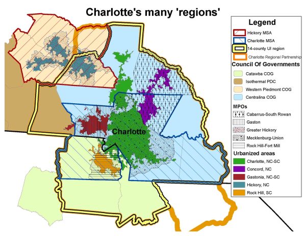
A region by many other names
Recent headlines have trumpeted the U.S. Census finding that between 2000 and 2010, the Charlotte “urbanized area” was the nation’s fastest growing among areas with 1 million or more people, at 64.6 percent.
But the statistic also highlighted the inconsistent, even chaotic, differences in how the so-called Charlotte region gets defined, based on who’s doing the defining.
The map above depicts some of the potential confusion. Consider: “Charlotte region” means something different if you’re the Centralina Council of Governments, a regional planning body, than it does if you’re the Charlotte Regional partnership, a regional economic development group. If you look at the Census Bureau’s Metropolitan Statistical Areas (MSAs) you see yet another different set of regions. Transportation planning is particularly chaotic, with five transportation-focused Metropolitan Planning Organizations (plus two Rural Planning Organizations) covering part of what most people would consider the greater Charlotte metro area.
The “Charlotte N.C.-S.C. urbanized area,” the region whose growth captured local attention, does not include many surrounding towns that by most definitions would be considered vital parts of the Charlotte region, such as Belmont, Mount Holly, Gastonia, Harrisburg, Concord, Kannapolis or Rock Hill. This “urbanized area” is far different from Charlotte’s more well-known six-county MSA, formally known as the Charlotte-Gastonia-Concord MSA. The MSA ranked No. 4 in metro area growth 2000-2010. The UNC Charlotte Urban Institute defines the Charlotte region as a 14-county area.
Even the term “urban” isn’t universally understood, noted Mitchell Silver, national president of the American Planning Association and Raleigh’s planning director, speaking Thursday in Charlotte. “Depending on when you were born,” he said, “ ‘urban’ means different things to different people.” And nowadays, he said, the word “urban” is often used not as a geographical term, but with a popular culture connotation.
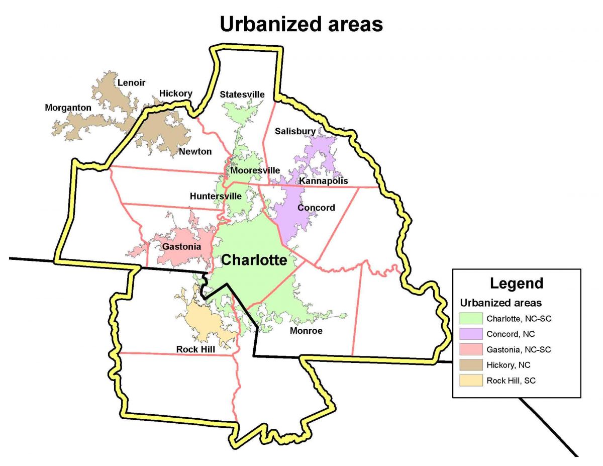
So, what is the “Charlotte N.C.-S.C. urbanized area,” and how is it defined? It’s complicated; the definition involves a complex Census Bureau formula that takes into account historical population centers. For the detailed answer click here. That site contains maps that show, as examples, how individual census blocks and block groups are built into urbanized areas for Danville, Ill. Basically, small areas of dense population and development are grouped, and even connected in “jumps” based on a set of criteria to create regions of urbanization.
In the Charlotte region, you can see that the surrounding cities that in earlier years met the threshold of 50,000 population form their own urbanized areas. Concord, Hickory, Gastonia and Rock Hill are the centers of their own urbanized regions. That leaves a long Charlotte “urbanized area” from Statesville south to Monroe.
It also helps explain how the Charlotte urbanized region placed first in population growth among larger U.S. cities. The Census’ methodology put most of the fastest-growing areas in our region into Charlotte’s urbanized area, and left out some slower-growing areas, such as Gaston County.
The cities ranking just below Charlotte in rate of urbanized area growth were Austin, Texas, at 51.1 percent, and Las Vegas-Henderson, Nev., at 43.5 percent. The Charlotte and Austin areas also had the highest rates of land area change, increasing by 70.5 percent and 64.4 percent, respectively, the Census Bureau said. Click here to read the Census press release.