Maps
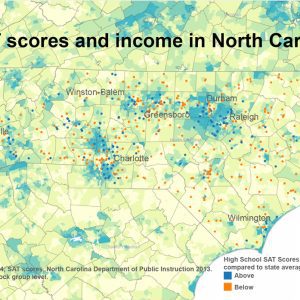
Want to know which of the state’s public high schools have above-average SAT scores? A map of income is a good place to start. Nationally, average SAT scores have bumped along in a narrow range since the late 1980s. (Read more.) A similar pattern is evident in North Carolina’s state-level scores over time. Comparing individual […]

Although the city arborist says Charlotte’s trees are healthy enough, for now, that no more aerial spraying to kill cankerworms is planned for next spring, the city’s infestation with the leaf-munching caterpillars remains high. Learn More Click here to see all of City Arborist Don McSween’s presentation. At a City Council meeting Monday, City Arborist […]
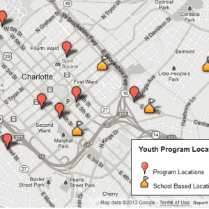
As part of the 2009 youth needs assessment, the institute inventoried youth workforce development programs in Mecklenburg County. The resulting Youth Services Catalog includes all organizations that provide workforce development services for at-risk and disconnected youth in the Charlotte area. It contains a range of information on each program/organization, including basic contact information, whom it […]
As part of the 2009 youth needs assessment, the institute inventoried youth workforce development programs in Mecklenburg County. The resulting Youth Services Catalog includes all organizations that provide workforce development services for at-risk and disconnected youth in the Charlotte area. It contains a range of information on each program/organization, including basic contact information, whom it […]

The carbon footprint of a household can vary greatly based on income and location. Researchers from UC Berkeley included these factors in a new analysis. The result is a set of interactive maps that show carbon footprints based on ZIP codes.** Household greenhouse gas emissions are lower in central cities compared to suburbs, but the […]

Between 2006 and 2013, the rate of N.C. high school students graduating on time (in four years) has increased from 68.3 percent to 82.5 percent. The state’s two largest districts, Wake and Charlotte-Mecklenburg, now have the same rate, 81 percent. With our interactive dashboards, below, you can explore the data for all districts in North […]

Development patterns along Charlotte’s Blue Line, which opened in November 2007, show a mixed bag of more low-density neighborhoods than planners recommend, but still a blend of homes, workplaces and stores. That means the corridor is brimming with opportunity for its 15 station areas to develop more intensely, and in a way that puts walkable, […]

It’s no secret that the Charlotte region experienced a huge influx of new residents in recent decades. The region has consistently ranked among the nation’s fastest-growing. All those newcomers also needed homes – so new homes were built by the thousands. The recently released American Community Survey 2007-2011 five-year estimates, reflected in the interactive map […]

As Charlotte-Mecklenburg Schools strives to meet the needs of all 141,171 students, part of its charge is to ensure that all students are ready for either careers or college. Of the almost 40,000 CMS high school students, how many will graduate ready for college? AP as a measure of college readiness CMS has clearly stated […]

Recent changes to the way metropolitan areas are defined added nearly a half-million in population to Charlotte’s MSA, making it the 23rd most populous MSA in the country. What happened in other metros across the country? Some saw great changes in their definitions, like Charlotte, while others remained entirely intact. The Charlotte Regional Indicators project […]
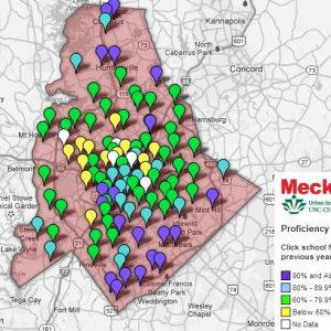
The UNC Charlotte Urban Institute has partnered with MeckEd to provide a series of interactive maps that allow the public to do their own exploration of CMS schools. Those maps have now been combined into a new interface that creates an integrated school data resource. The maps show data on teacher turnover, student suspension rates, […]

In January, the Charlotte metro area population was 1.8 million people. In February, the metro area population was 2.3 million. Where did the half-million people come from? New boundaries were drawn for metropolitan statistical areas. In February 2013, new MSA definitions* took effect. The changes, based on commuting ties among counties, are part of an […]