Maps

Charlotte region: Getting older, growing younger
The nation as a whole is getting older, but variations in population growth and immigration can create big differences in the median age from place to place. The Charlotte region is no exception. While Mecklenburg’s median age has risen only marginally, some neighboring counties are getting noticeably older. It turns out that migration, diversity and […]

Charlotte region: Understanding the new diversity
The rise in the number of Hispanic, Asian and multiracial residents has been the biggest change in population diversity in the Charlotte region for more than a decade. The growth and distribution of these groups has not been even, which creates notable differences among the region’s urban, suburban and rural communities. Explore a host of […]
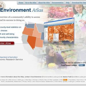
The USDA food atlas
This interactive map of the U.S. displays data on food availability, local foods, health and socioeconomic statistics. Data are displayed at the state or county level, depending on availability. Staff

The decline (and rise?) of Carolina manufacturing
After decades of decline, manufacturing jobs across the country have seen a modest uptick. This long period of industry restructuring has left a strikingly different geography of manufacturing in the Carolinas; we still make furniture and textiles, but that’s no longer the whole story. New industries have taken root. Many offer higher wages than the […]
Carolinas growth update: urban changes, rural losses
Where are urban regions growing – in their cores or suburbs? What is happening in rural areas? New population figures have fostered speculation about what growth in urban regions will be like in the future. For rural parts of the Carolinas, the issue isn’t about growth at all, but widespread decline in population. The 2000s […]
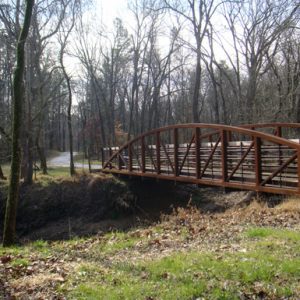
Carolina Thread Trail takes steps toward reality
Imagine being able to hop on your bicycle in Huntersville and pedal on greenways and trails to your job in the UNC Charlotte area. How about a Saturday morning hike from downtown Lincolnton to the Catawba County line, with the kids? A regional system of trails and greenways is beginning to emerge that promises to […]

YMCA Maps
The UNC Charlotte Urban Institute collaborated with Council for Children’s Rights to map all YMCA locations in Mecklenburg County. These locations were then overlaid onto maps of individual indicators from the 2010 Charlotte Neighborhood Quality of Life Study. Finally, four of these indicators (teen births, high school dropouts, juvenile arrests, and food stamp recipients) were […]
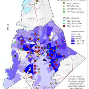
Youth Risk Index and YMCA and Title 1 School Locations
This map shows the locations of YMCA facilities and youth programs (Starfish Academy and the Y Achievers Program) as well as Title I schools, all in relation to the youth risk index of Charlotte neighborhoods. Starfish Academy is a YMCA program that serves pre-k through second grade students who are currently reading below grade level […]
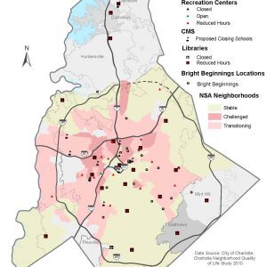
See the Bright Beginnings Map
This map shows the location of public recreation centers, libraries, and schools in relation to the quality of life status of Charlotte neighborhoods, with particular emphasis on facilities that have been closed or now have reduced hours. It was created by the UNC Charlotte Urban Institute, in collaboration with Council for Children’s Rights, to determine […]
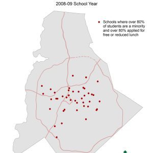
Maps of High-Poverty and High-Minority Schools
This series of maps shows the percent of students at each school in the Charlotte-Mecklenburg Schools (CMS) district that are a racial minority and the percent that applied for free/reduced lunch at two points in time, the 2001-02 and 2008-09 school years. The final two maps show only those schools in which the proportion of […]